Sunday, May 4, 2014

Is Mother Earth Angry? Signs of the Times April 2014

The SOTT Report | May 4, 2014 | Subscribe

The following video compiles footage of 'signs of the times' from around the world during the past month of April 2014. From 'strange lights' in the skies to extreme weather events, from geological upheaval in the form of volcanic eruptions, sinkholes, landslides and earthquakes to loud booms rattling communities and meteor fireballs turning night into day, the Big Blue Marble is rocking and rolling!

Dallas Ends 5 Decades of Water Fluoridation: Saves $1 Million Annually in the Process

Natural Society | May 3, 2014 | Christina Sarich

It is taking effect in cities across the nation. Anti-fluoridation activists and knowledgeable consumers have finally tipped the scale, and now Dallas will cease poisoning its water supply with sodium fluoride, saving taxpayers a million dollars annually, along with a few IQ points.

After months of regular visits by citizens to city council meetings, the Dallas City Council decided last week to stop water fluoridation. Perhaps it was economic incentive alone that allowed the council to decide to end five decades of water fluoridation, or the tireless work of citizens who continuously probed council members about why they would fluoridate city water when it has been proven to be very dangerous to human health.

NBC 5 Dallas Fort Worth reported that the results from the last meeting surprised anti-fluoridation activists, who have been trying to get someone to listen to them about this industrial chemical and its risks for years.

Dallas City Council Member Sheffie Kadane said he discussed ending fluoridation with City Manager A.C. Gonzalez, citing Kadane as saying:
“We don’t need it and we’d just save a million dollars that we can use for something else. … We’re looking into seeing what we can do immediately so we can get those funds up front now.”
Kadane was backed by Council members Scott Griggs and Jennifer Staubach Gates. Anti-fluoridation activist Regina Imburgia said:
“Yeah. … This is major big. I knew we would prevail. It only makes sense. We’re spending too much money on an ineffective program”.
Imburgia said that there was no need to put fluoride in water when it had obvious health risks, and that people who really wanted fluoride to prevent tooth decay could just squeeze it out of a tube of toothpaste.

City council members focused on the savings of ending fluoridation, rather than the fact that its removal from municipal water was a public health concern.

Read: Rejection – 5 Fluoride Victories of 2014

Health Concerns over Toxic Fluoride 

There have been multiple studies proving that fluoride is not metabolized easily by the body, and accumulates in the tissues and bones (much like glyphosate – a main ingredient in pesticides). Other studies have proven that accumulated fluoride can alter the activities of some enzymes involved in free-radical metabolism and whole brain functioning. Philippe Grandjean MD from the Department of Environmental Health at the Harvard School of Public Health, and Philip Landrigan MD, from the Icahn School of Medicine at Mt Sinai, New York, state that industrial chemicals can injure the developing brain in children, lowering their memory and IQ.

Fluoride is among five scientifically identified industrial chemicals that lead to neurological impairment:
  • Lead
  • Methylmercury
  • Polychlorinated biphenyls
  • Arsenic
  • Fluoride
Researchers Grandjean and Landrigan postulate that there are even more neurotoxicants which remain undiscovered, and propose a global prevention strategy to control what they describe as the pandemic of developmental neurotoxicity.

Anti-fluoridation advocates in Dallas will get their water fluoride free now, even if it is the last decades’ poor economy driving the point home to city officials.

Saturday, May 3, 2014

Oil industry, US government woefully unprepared for spill in Arctic – study

Reuters / U.S. Coast Guard / Petty Officer
3rd Class Grant DeVuyst / Handout
RT | May 3, 2014 

A new study says there is a lack of both scientific data and preparedness on the part of private and public entities to properly address an oil spill in the Arctic Ocean, which global powers and industry expect to exploit for energy exploration.

Climate change is thawing sea ice in the Arctic, opening up new opportunities for energy development. Approximately 30 percent of the world’s undiscovered natural gas and about 15 percent of its untapped oil lie in the Arctic. But the majority, 84 percent, of the estimated 90 billion barrels of oil and 47.3 trillion cubic meters of gas remain offshore.

Waiting for eager energy developers are some of the world’s most extreme weather conditions “and environmental settings, limited operations and communications infrastructure, a vast geographic area, and vulnerable species, ecosystems, and cultures,” the National Research Council wrote.

The five countries with territorial claims in the Arctic – Canada, Denmark, Norway, Russia, and the United States – have stated intentions to develop these reserves, if they haven’t begun already.

Yet the National Research Council’s new study – funded by US federal agencies and the leading trade group for the oil industry, the American Petroleum Institute – found that energy companies currently lack Arctic oil spill response plans, as it is their responsibility to address such an event. That said, public entities often take the lead in spill response actions, yet the US government does not have infrastructure capabilities in place despite its rush to establish dominance in the region.

“The lack of infrastructure and oil spill response equipment in the U.S. Arctic is a significant liability in the event of a large oil spill,” the report states. “Building U.S. capabilities to support oil spill response will require significant investment in physical infrastructure and human capabilities, from communications and personnel to transportation systems and traffic monitoring.”

The “significant investment” on infrastructure could come from public-private partnerships, the report suggests, though the politics of offering industry further subsidies may be problematic.

Adequate research into what awaits industry in the extreme cold of Arctic waters is also lacking, the report said. There is little understanding of how the low temperatures would affect both spilled oil and commonly-used techniques to reverse the effects of a spill, such as the spread of chemical dispersants. The report goes as far as suggesting that the only way to know is to conduct a controlled oil spill.

“Laboratory experiments, field research, and practical experience gained from responding to past oil spills have built a strong body of knowledge on the properties of spilled oil and response techniques. However, much of this work has been done for temperate regions,” the report reads.

“There is…a need to validate current and emerging oil spill response technologies in Arctic environmental conditions on operational scales. Carefully planned and controlled field releases of oil in the U.S. Arctic would improve the understanding of oil behavior [the Arctic] and allow for the evaluation of new response strategies specific to the region.”

Three oil and gas companies – ConocoPhillips, Norwegian multinational Statoil, and Shell Oil – have received approval to explore the US Arctic territory.

Shell has spent $6 billion so far in ultimately unsuccessful Arctic drilling operations, Mint Press News reported. It was an incident in 2012, involving a Shell oil-drilling rig, that has provided the starkest indication of what lies ahead for companies in the region.

In a rush to avoid an upcoming tax liability about to go into effect, Shell decided to drag its top rig, the Kulluk, around 1,700 miles through frigid Arctic waters despite warnings from the tow ship’s captain.

The Kulluk, reportedly carrying 150,000 gallons of fuel, eventually broke free from the towing ship floating off into an ecologically-sensitive area. The rig and its crew had to be rescued by the US Coast Guard, which recently released a report on the incident that slams Shell for “inadequate assessment and management of risks.”

“Vessels and the operations they conduct are growing more complex, and the risks that accompany these operations increase, whether in Alaskan waters or not,” wrote Joseph A. Servidio, a Coast Guard rear admiral, in the report. “The failure to adequately understand, respect, and not complacently assume past practice will address new risks, is critical both in practice and in company culture.”

According to the United Nations' sea convention, any country has sovereign rights to resources within 200 nautical miles of its territorial waterways.

The five countries with territorial claims have long preached cooperation in the region, going as far as setting up an Arctic Council that the nations take turns leading. In 2015, the US will assume the leadership role as a warming planet has opened up new opportunities. These commercial interests worry advocates of ecologically-intelligent approaches to the Arctic.

“The Arctic Council should be a forum focused on protecting the Arctic environment, yet we see it more and more talking about protecting economic interests in the region,” John Deans, an Arctic campaigner with Greenpeace USA, told Mint Press.

Deans said that for his organization, which has environmental interests in mind, the lack of scientific information about Arctic drilling consequences is a red flag, yet governments and industry are highly unlikely to slow their pace.

“In our view, if you don’t know enough about a place – in this case, what either an oil spill or a response would look like – then you really shouldn’t be up there to drill in the first place,” he said.

Proof that Earth is bombarded by 10 times more asteroids than previously thought

© Natural News
Natural News | May 2, 2014 | J. D. Heyes

Three former astronauts have presented evidence that Earth has experienced many more large-scale asteroid impacts over the past decade than previously believed.

In fact, they say, the number is anywhere from three to 10 times more.

According to reports, a new visualization of data from a nuclear weapons warning network shows that "the only thing preventing a catastrophe from 'city-killer' sized asteroids is blind luck."

The astronaut group says that since 2001, 26 atomic bomb-scale explosions have taken place in remote locations around the world, far from populated areas, as evidenced by a nuclear weapons test-warning network. In a recent press release regarding them, the B612 Foundation's CEO, Ed Lu, said:

"This network has detected 26 multi-kiloton explosions since 2001, all of which are due to asteroid impacts. It shows that asteroid impacts are NOT rare--but actually 3-10 times more common than we previously thought. The fact that none of these asteroid impacts shown in the video was detected in advance is proof that the only thing preventing a catastrophe from a 'city-killer' sized asteroid is blind luck. The goal of the B612 Sentinel mission is to find and track asteroids decades before they hit Earth, allowing us to easily deflect them."

Preventing a major future asteroid impact

The B612 Foundation has partnered with Ball Aerospace to build the Sentinel Infrared Space Telescope Mission, which, once positioned in solar orbit closer to the sun than the earth, will look outwards in infrared to detect hundreds of thousands of as-yet-unknown near-Earth objects that are larger than 140 meters. This privately funded space craft is scheduled to launch in the 2017-18 time frame aboard a SpaceX Falcon 9 rocket.

Leonard David at Space.com noted that bureaucratic inertia is making it more difficult for researchers to study and characterize asteroid strikes on Earth, which are apparently much more common than previously thought.

The red tape affects the use of the U.S. government's space assets that assist scientists in the study of "airbursts" like the meteor that exploded without warning over Russia in 2013. "At issue," wrote David, "is the ability to combine space data with outputs from a global network of seismic, infrasound and hydroacoustic sensors that have been deployed worldwide to provide treaty verification for a nuclear test ban."

Monitoring continues

The network, known as the International Monitoring System (IMS is managed by the Comprehensive Nuclear Test Ban Treaty Organization [CNTBTO]), has in recent years detected shock waves from a number of airbursts, which has provided additional evidence of more frequent asteroid impacts.

"Ideally, matching observations from spacecraft with measurements from CTBTOs infrasound detectors would give scientists more of a heads-up on what's raining down on Earth," David wrote.

In 2013, the Air Force's Space Command signed a memorandum of agreement with NASA's Science Mission Directorate. The document, signed Jan. 18, listed a number of specifics for the public release of meteor data from sources like high-flying, secretive federal government space sensors.

With the agreement, NASA's Near Earth Object Observation Program started taking in information on airburst events that were based on an analysis of data collected by federal government sensors.

"Details of atmospheric meteor explosions, as recorded by U.S. military spacecraft sensors, were posted on a publicly accessible NASA website run by the Jet Propulsion Laboratory (JPL) in Pasadena, Calif.," David wrote.

Sources:

http://phys.org

http://news.yahoo.com

Truck carried 27 miles by tornado across Arkansas

© Photo: Mark Wilson, Getty Images
A police officer walks past an overturned
car near a home that was destroyed by a
tornado on April 29, 2014, in Vilonia, Ark.
Sott.net | May 2, 2014 | Doyle Rice \ USA Today

A truck was reportedly carried 27 miles by a tornado Sunday night in Arkansas, according to meteorologist Darby Bybee of KHBS-TV in Fort Smith.

Bybee reported that the truck was carried from Mayflower, Ark., to near Vilonia, Ark., a distance of about 27 miles. A report from the National Weather Service in Little Rock notes that an EF4 tornado - with winds of at least 180 mph - traveled 41 miles on a path that included both Mayflower and Vilonia.

The tornado killed 15 people.

Many cars were tossed around and destroyed, some mangled beyond recognition, Bybee said. He said it can be difficult to make an insurance claim on a car that can't be found or identified.

Long-distance transport of large objects in tornadoes has been reported before, though Randy Cerveny, a geography professor at Arizona State University, said, "I haven't heard of trucks being thrown that far."

In 1877, a tornado in Illinois reportedly carried "the spire, vane and guilded ball of a Methodist church" 15 miles, according to his book Freaks of the Storm.

"A 1966 Mississippi tornado reportedly lifted a mother and her 2-year-old daughter in the family Volkswagen into the air and carried it 70 feet through the air," he added. "Finally, the tornado dropped the small car on the top of the local electrical company building.

"Amazingly, the Volkswagen sustained only a couple of dents in the hood and miraculously neither the mother nor her daughter was injured," he wrote.

The world record for the object carried farthest by a tornado: A personal check was carried 223 miles on April 11, 1991, from Stockton, Kan., to Winnetoon, Neb.

World weather records are kept in the World Meteorological Organization's Weather and Climate Extremes archive, Cerveny said.

© Photo: National Weather Service
An EF4 tornado carved a ferocious 41-mile path through
central Arkansas on Sunday night, killing 15 people.

Friday, May 2, 2014

Fracking-linked earthquakes likely to worsen – seismologists

David McNew / Getty Images / AFP
RT | May 2, 2014

Ongoing hydraulic fracking operations will only exacerbate seismic activity, leading to heightened earthquakes in areas where wastewater is injected deep underground, according to new research.

To unleash natural gas, hydraulic fracturing - or fracking - requires large volumes of water, sand, and chemicals to be pumped underground. Scientists attending the Seismological Society of America (SSA) annual meeting said Thursday that this storage of wastewater in wells deep below the earth’s surface, in addition to fracking’s other processes, is changing the stress on existing faults, which could mean more frequent and larger quakes in the future.

Researchers previously believed quakes that resulted from fracking could not exceed a magnitude of 5.0, though stronger seismic events were recorded in 2011 around two heavily drilled areas in Colorado and Oklahoma.

“This demonstrates there is a significant hazard,” said Justin Rubinstein, a research geophysicist at the US Geological Survey (USGS), according to TIME magazine. “We need to address ongoing seismicity.”

Not all of the more than 30,000 fracking disposal wells are linked to quakes, but an accumulating body of evidence associates an uptick in seismic activity to fracking developments amid the current domestic energy boom.

The amount of toxic wastewater injected into the ground seems to provide some clarity as to what causes the earthquakes. A single fracking operation uses two to five million gallons of water, according to reports, but much more wastewater ends up in a disposal well.

“There are so many injection operations throughout much of the US now that even though a small fraction might induce quakes, those quakes have contributed dramatically to the seismic hazard, especially east of the Rockies,” said Arthur McGarr, a USGS scientist. The USGS researchers spoke with reporters via conference call on Thursday.

Scientists believe the cumulative effect of these operations could result in larger quakes becoming more common over time.

“I think ultimately, as fluids propagate and cover a larger space, the likelihood that it could find a larger fault and generate larger seismic events goes up,” Gail Atkinson, professor of earth sciences at Western University in Ontario, Canada, said at the SSA meeting.

Seismologists say that widespread oil and gas development in one area could create hazardous quakes in nearby areas not equipped to handle activity above a low-level quake.

“With these huge wells, the pressure they create can travel tens of kilometers,” said Katie Keranen, assistant professor of geophysics at Cornell University.

As fracking spreads to new areas like Ohio that haven’t traditionally experienced many earthquakes, the scientists said more research is needed to understand the risks involved, for policymakers and the public.

“There’s a very large gap on policy here,” said Atkinson. “We need extensive databases on the wells that induce seismicity and the ones that don’t.”

The scientists said energy industry players must offer more information on their fracking operations, and data on these actions must be made publicly available more often.

“There are minimums in terms of what needs to be recorded - injection pressure and volume - but these are only made available to the public once a year,” Rubenstein said. “We need more information reported more frequently to do the science correctly.”

Last month, state geologists in Ohio said the link between fracking and five minor quakes in the state was “probable.”

Outside of increased seismic activity, fracking has been linked to groundwater contamination, exacerbation of drought conditions, and a laundry list of health concerns for humans and the local environment.

May Day strides along the planet

VOA | May 1, 2014

May 1 is a holiday known for its pagan roots also commonly called Labour day. According to the source, three thousand years ago in Italy, the goddess Maya was renowned. View more..
© Reuters
Traditional May Day labour march in Marseilles


Solved! How Ancient Egyptians Moved Massive Pyramid Stones

The Pyramids of Giza, built between 2589 and 2504 BC.
Credit: Dan Breckwoldt | Shutterstock
Live Science | May 1, 2014 | Denise Chow


The ancient Egyptians who built the pyramids may have been able to move massive stone blocks across the desert by wetting the sand in front of a contraption built to pull the heavy objects, according to a new study.

Physicists at the University of Amsterdam investigated the forces needed to pull weighty objects on a giant sled over desert sand, and discovered that dampening the sand in front of the primitive device reduces friction on the sled, making it easier to operate. The findings help answer one of the most enduring historical mysteries: how the Egyptians were able to accomplish the seemingly impossible task of constructing the famous pyramids.

To make their discovery, the researchers picked up on clues from the ancient Egyptians themselves. A wall painting discovered in the ancient tomb of Djehutihotep, which dates back to about 1900 B.C., depicts 172 men hauling an immense statue using ropes attached to a sledge. In the drawing, a person can be seen standing on the front of the sledge, pouring water over the sand, said study lead author Daniel Bonn, a physics professor at the University of Amsterdam. [Photos: Amazing Discoveries at Egypt's Giza Pyramids]

"Egyptologists thought it was a purely ceremonial act," Bonn told Live Science. "The question was: Why did they do it?"

Bonn and his colleagues constructed miniature sleds and experimented with pulling heavy objects through trays of sand.

When the researchers dragged the sleds over dry sand, they noticed clumps would build up in front of the contraptions, requiring more force to pull them across.

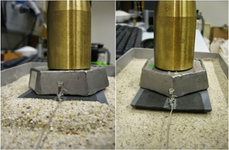
Adding water to the sand, however, increased its stiffness, and the sleds were able to glide more easily across the surface. This is because droplets of water create bridges between the grains of sand, which helps them stick together, the scientists said. It is also the same reason why using wet sand to build a sandcastle is easier than using dry sand, Bonn said.

A large pile of sand accumulates in front of the
sled when it is pulled over dry sand (left).
On the wet sand (right) this does not happen.
Credit: Daniel Bonn/University of Amsterdam
But, there is a delicate balance, the researchers found.

"If you use dry sand, it won't work as well, but if the sand is too wet, it won't work either," Bonn said. "There's an optimum stiffness."

The amount of water necessary depends on the type of sand, he added, but typically the optimal amount falls between 2 percent and 5 percent of the volume of sand.

"It turns out that wetting Egyptian desert sand can reduce the friction by quite a bit, which implies you need only half of the people to pull a sledge on wet sand, compared to dry sand," Bonn said.

The study, published April 29 in the journal Physical Review Letters, may explain how the ancient Egyptians constructed the pyramids, but the research also has modern-day applications, the scientists said. The findings could help researchers understand the behavior of other granular materials, such as asphalt, concrete or coal, which could lead to more efficient ways to transport these resources.

Follow Denise Chow on Twitter @denisechow. Follow Live Science @livescience, Facebook & Google+. Original article on Live Science.

Thursday, May 1, 2014

Lessons of Nuclear History - Harvey Wasserman

eon3 | Apr 30, 2014 | CHANNEL


Investigative journalist, life-long nuclear free campaigner, and solartopian thinker Harvey Wasserman had this to say at an event marking the 3rd anniversary of the still-on-going Fukushima nuclear disaster, held at the BC Space Gallery in Laguna Beach, CA. For more info: http://www.nukefree.org/ http://www.sanclementegreen.org/ http://sanonofresafety.org/ http://bcspace.com/

National Park Service Creates an Historic Landmark that can’t be Visited

Recovery team with filled body
bags at Grand Canyon crash
site in 1956 (photo: Getty/LIFE)
ALLGOV | Apr 30, 2014 | Noel Brinkerhoff

A remote stretch of the Grand Canyon has been declared a historic landmark to commemorate a fatal plane crash that proved instrumental in the development of U.S. aviation. But Americans won’t be able to visit the landmark because the National Park Service (NPS) intends to keep its location a secret.

The landmark covers an area of rugged terrain about 1.5 square miles in size within the Grand Canyon, above which two planes collided in midair on June 30, 1956.

Flying in inclement weather, a United Airlines Douglas DC-7 crashed into a TWA Lockheed L-1049 Super Constellation. All 128 people aboard the two planes were killed, making it the deadliest accident in commercial aviation history at the time.

The accident prompted the federal government to expand its regulatory authority over the industry, culminating in the establishment of the Federal Aviation Administration two years later.

It also encouraged the development of nationwide radar, collision avoidance systems, flight-data recorders, and more advanced navigation equipment.

Given the turning points in aviation operations that followed the crash, NPS officials decided it was time to designate the area as a historic landmark.

Alexandra Lord, branch chief of the National Historic Landmarks Program in Washington, DC, admits the marker represents the first time the agency has given such a designation to a crash site. It also may be the first time that a landmark was created for something that happened exclusively in the air.

“In some ways we can argue that the crash itself—which led to the scattering of pieces over a huge debris field—is what's crucial. And it sort of doesn't matter if you think of it as on the air or on the ground,” Lord told The Atlantic.

Efforts were made to retrieve human remains after the accident, but no bodies were found intact, making identification difficult or impossible. The remains of 29 United victims were buried in four coffins, and 66 of the 70 TWA passengers were interred in a mass grave.

Although most of the wreckage was removed, to this day the area reportedly still contains some remnants of the destroyed aircrafts.

Hikers have been banned from the area since the 1950s, but it wouldn’t be wise anyway for the curious to make the trek, advised Lord. “It’s extremely remote, so it would take a very long time for someone to get there backpacking and it would be very difficult to reach,” she said.

One man did reach the crash site a year after the disaster. He claimed to have found various items from the planes, including some burnt coins and a TWA spoon.

The NPS wants to preserve the area and consequently won’t reveal the site’s coordinates. In fact, it redacted that information from the Historic Landmark Nomination document (pdf). “But we know where it is,” said Lord, “and we're going to work to preserve it.”