Showing posts with label Hurricanes. Show all posts

Saturday, October 18, 2014

NASA satellites sees a question mark in Tropical Storm Ana as it approaches Hawaii

© NASA
NOAA's GOES-East satellite captured this
image of Tropical Storm Ana approaching Hawaii
in the Central Pacific Ocean on Oct. 17
at 1500 UTC (11 a.m. EDT).
SOTT | Oct 17, 2014 | NASA

NOAA's GOES-West satellite captured an image of Tropical Storm Ana that showed the outer clouds were already reaching the big island by 11 a.m. EDT and the storm resembled a giant question mark.

Tropical Storm Ana was nearing hurricane strength mid-day on Oct. 17 and the Central Pacific Hurricane Center (CPHC) expects the storm to become a hurricane before reaching the big island of Hawaii.

NOAA's GOES-West satellite took an infrared picture of Tropical Storm Ana as it was approaching Hawaii on Oct. 17 at 11 a.m. EDT (5 a.m. HST). Ana looked like a giant question mark in the infrared image, as a large band of thunderstorms wrapped into the center from the eastern side of the storm and extended south of the storm.

Despite the storm looking like a question mark from space, the Central Pacific Hurricane Center said that there is no question the storm has been intensifying.

A Tropical Storm Watch remained in effect for Hawaii County on Oct. 17. A tropical storm watch means that tropical storm conditions are possible within the watch area, in this case within 24 to 36 hours. Interests elsewhere in the main Hawaiian Islands, and in the Papahanaumokuakea Marine National Monument Area, should monitor the progress of Ana.

The CPHC expects tropical-storm-force winds to affect the Big Island of Hawaii by tonight, Oct. 17. In addition, heavy rainfall with total rain accumulations between 6 and 8 inches, with isolated totals of 12 inches are possible. Heavy rain could potentially affect the other islands Saturday and Sunday. This rainfall could cause life-threatening flash floods and mud slides.


In addition to the winds and heavy rainfall, dangerous surf will precede and Ana. CPHC noted that large swells are expected to build over the eastern end of the main Hawaiian island chain today (Oct. 17) through Saturday. These large swells will continue to spread up the island chain through the weekend. Surf produced by these swells could potentially be damaging along exposed south and southeast shorelines beginning later today and Saturday, and persisting through the weekend in some areas.

At 11 a.m. EDT (5 a.m. HST) maximum sustained winds were near 70 mph (110 kph) and Ana is expected to become a hurricane later in the day with gradual weakening expected Saturday and Sunday. The center of tropical storm Ana was located near latitude 15.7 north, longitude 154.2 west. Ana was moving toward the west-northwest near 14 mph (22 kph)

Ana is expected to turn slightly to the northwest and slow over the weekend of Oct. 18 and 19. After a brief stint as a hurricane overnight Oct.17 and early Oct. 18 when it will be west of the Big Island, it is expected to weaken back to a tropical storm and move almost parallel to the Hawaiian Islands while remaining over water, west of the islands. By mid-week next week, around Oct. 18, the CPHC expects Ana to track through the French Frigate Shoals.

Tuesday, October 14, 2014

STARTLING: Super Typhoon Vongfong captured by ISS camera

RT | Oct 13, 2014 


COURTESY: NASA http://www.youtube.com/user/NASAgovVi...

The cameras on the ISS captured the video of Super Typhoon Vongfong on October 9, 2014.

The powerful typhoon has injured over 40 people on the Japanese island of Okinawa, and is now downgrading from a super-typhoon to a mere tropical storm. But at the peak of its strength it was a startling sight to see from the Earth’s orbit. FULL STORY: http://on.rt.com/4dj8ko

Wednesday, September 17, 2014

Hurricane Odile could bring catastrophic flooding from Tucson to Albuquerque NM in U.S. Southwest


Signs of the Times | Sep 16, 2014

Odile will unload tremendous rainfall over a large part of the Southwest United States that will run off the mountains and into the desert valleys and plains through the end of the week.

According to Western Weather Expert Ken Clark, "There is the potential for devastating, catastrophic and historic flooding in this scenario."

The heaviest rainfall will hit the Southwestern states of Arizona and New Mexico where a general 3 to 6 inches will fall, but local amounts of 10 inches or more are possible on the slopes of the mountains. Rainfall of 1 to 2 inches per hour can occur.

There is a significant risk to lives and property in the region.

"Not only will flash and urban flooding occur in this case, but there is the potential for major river flooding," Clark said.

This is the type of threat that can cause water to sweep through normally dry stream beds, called arroyos, and into villages, towns and major cities rapidly. Major roads can be damaged and some bridges along secondary roads could be swept away. Mudslides and dust storms can block roads in a few locations.

Read more..

Sunday, August 24, 2014

Southeast US on Alert for Future Tropical Storm Cristobal

© Accuweather.com
Accuweather | Aug 23, 2014

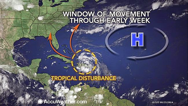
Tropical Storm Cristobal is expected to take shape later this weekend, then impact the Atlantic beaches and potentially other parts of the southeastern United States next week.

Tropical Depression Four formed over the Turks and Caicos Islands on Saturday afternoon. All interests across the southeastern U.S., the Bahamas and Turks and Caicos Islands should be keeping a close eye on the area of disturbed weather in the southwestern Atlantic.

Regardless of when Cristobal is named, torrential downpours, gusty squalls and rough surf will continue to spread from Hispaniola northwestward into the southern and central Bahamas as the weekend draws to a close. Some drenching showers and thunderstorms will even reach eastern Cuba.

"Heavy rainfall will raise the risk of flash flooding across the region, and in the case of Hispaniola may lead to roads being washed out and perhaps mudslides", stated AccuWeather.com Meteorologist Randy Adkins

Damaging winds will become an increasing concern for the Bahamas as Cristobal strengthens early next week.

Read more..

Friday, August 8, 2014

Hawaii prepares for first direct hit from hurricane in 22 years as second storm looms

Hurricane Iselle and Hurricane Julio (R) are pictured en route to
Hawaii in this August 5, 2014 NASA handout satellite image.
Hurricane Iselle is expected to make landfall on
Hawaii August 7, 2014.(Reuters / NASA)
RT | Aug 7, 2014

The Big Island of Hawai’i is bracing for a double whammy of hurricanes to make landfall between Thursday and Monday, according to the National Weather Service. The last time the archipelago took a direct hit from a hurricane was 1992.

Iselle, a Category 1 storm, is forecast to arrive on Hawai’i Thursday night local time, then weaken and continue on to the rest of the islands by Friday, according to Weather.com. The storm defied expectations that it would weaken to a tropical storm over the course of the day Wednesday. Iselle is roughly 300 miles east-southeast of Hilo, on the island’s eastern corner. It is moving quickly, at 15-20 mph.

"The real effects will probably be felt on the Big Island starting around noon" (6 p.m. ET) on Thursday, Norman Hui, a National Weather Service (NWS) meteorologist in Honolulu, told USA TODAY. "The worst of it will be tonight. This storm is holding together pretty well."

The storm is currently weakening, and forecasters are unsure whether it will make landfall as a hurricane or a tropical storm, Weather.com reported. At 7 a.m. Hawaiian time (5 p.m. GMT), Iselle had maximum sustained winds of 80 mph, placing it in the middle of the Cat-1 range (74-95 mph) on the Saffir-Simpson scale, according to the Central Pacific Hurricane Center (CPHC).

Read more..

Friday, April 11, 2014

Tropical Cyclone Hamish (18P) approaches Eastern Australia

 © eosnap.com
Earth Snapshot | Apr 8, 2014

Tropical Cyclone 18P HAMISH, located approximately 585 nm north-northwest of Brisbane, Australia, has tracked southeastward at 08 knots over the past 06 hours. The cyclone has rapidly intensified over the past 12 hours with DVORAK satellite intensity estimates from PGTW, KNES, and ABRF, indicating at the weakest a 130 knot system.

Hamish will continue to track along the east coast of Australia under the steering influence of deep layer ridging to the east while weakening. Increased vertical wind shear and land interaction will initiate this weakening.

Greater weakening is expected nearer to tau 24, and through the duration of the forecast period, as the system moves even closer to land and a branch of the subtropical jet. Maximum significant wave height at 071200z is 19 feet.

Tuesday, March 4, 2014

We Deserve a Better Indicator of Societal Well-Being Than the GDP

Image courtesy of EcoWatch.
It's Our Economy | Mar 3, 2014 | David Suzuki
“Yet the gross national product does not allow for the health of our children, the quality of their education or the joy of their play. It does not include the beauty of our poetry or the strength of our marriages, the intelligence of our public debate or the integrity of our public officials. It measures neither our wit nor our courage, neither our wisdom nor our learning, neither our compassion nor our devotion to our country. It measures everything in short, except that which makes life worthwhile.” —Robert F. Kennedy.
Governments, media and much of the public are preoccupied with the economy. That means demands such as those for recognition of First Nations treaty rights and environmental protection are often seen as impediments to the goal of maintaining economic growth. The gross domestic product has become a sacred indicator of well-being. Ask corporate CEOs and politicians how they did last year and they’ll refer to the rise or fall of the GDP.

It’s a strange way to measure either economic or social well-being. The GDP was developed as a way to estimate economic activity by measuring the value of all transactions for goods and services. But even Simon Kuznets, an American economist and pioneer of national income measurement, warned in 1934 that such measurements say little about “the welfare of a nation.” He understood there’s more to life than the benefits that come from spending money.

My wife’s parents have shared our home for 35 years. If we had put them in a care home, the GDP would have grown. In caring for them ourselves we didn’t contribute as much. When my wife left her teaching job at Harvard University to be a full-time volunteer for the David Suzuki Foundation, her GDP contribution fell. Each time we repair and reuse something considered disposable we fail to contribute to the GDP.

To illustrate the GDP’s limitations as an indicator of well-being, suppose a fire breaks out at the Darlington nuclear facility near Toronto and issues a cloud of radioactivity that blows over the city, causing hundreds of cases of radiation sickness. All the ambulances, doctors, medicines and hospital beds will jack up the GDP. And if people die, funeral services, hearses, flowers, gravediggers and lawyers will stimulate GDP growth. In the end, cleaning up the Darlington mess would cost billions and produce a spike in the GDP.

Extreme weather-related events, such as flooding and storms, can also contribute to increases in GDP, as resources are brought in to deal with the mess. Damage done by Hurricanes Katrina and Sandy and the BP oil spill in the Gulf of Mexico added tens of billions to the GDP. If GDP growth is our highest aspiration, we should be praying for more weather catastrophes and oil spills.

The GDP replaced gross national product, which was similar but included international expenditures. In a 1968 speech at the University of Kansas, Robert F. Kennedy said, “Too much and for too long, we seemed to have surrendered personal excellence and community values in the mere accumulation of material things … Gross national product counts air pollution and cigarette advertising, and ambulances to clear our highways of carnage. It counts special locks for our doors and the jails for the people who break them. It counts the destruction of the redwood and the loss of our natural wonder in chaotic sprawl. It counts napalm and counts nuclear warheads and armored cars for the police to fight the riots in our cities … and the television programs which glorify violence in order to sell toys to our children.

“Yet the gross national product does not allow for the health of our children, the quality of their education or the joy of their play. It does not include the beauty of our poetry or the strength of our marriages, the intelligence of our public debate or the integrity of our public officials. It measures neither our wit nor our courage, neither our wisdom nor our learning, neither our compassion nor our devotion to our country. It measures everything in short, except that which makes life worthwhile.”

We deserve better indicators of societal well-being that extend beyond mere economic growth. Many economists and social scientists are proposing such indicators. Some argue we need a “genuine progress indicator,” which would include environmental and social factors as well as economic wealth. A number of groups, including Friends of the Earth, have suggested an Index of Sustainable Economic Welfare, which would take into account “income inequality, environmental damage, and depletion of environmental assets.” The Kingdom of Bhutan has suggested measuring gross national happiness.

Whatever we come up with, it has to be better than GDP with its absurd emphasis on endless growth on a finite planet.

Originally published in EcoWatch.

Sunday, February 16, 2014

Winter Hurricane Atlantic storm brings more flood misery to drenched Britain: heaviest rainfall in 250 years

Winter Hurricane Atlantic storm brings more flood misery to drenched Britain: heaviest rainfall in 250 years
Feb 14, 2014 | The Extinction Protocol

BRITAIN – Princes William and Harry rolled up their sleeves Friday to help out with flood defense efforts as Britain braces for another hammering Friday from a major storm off the Atlantic. The princes showed up at 6 a.m. local time in the flood-hit village of Datchet, west of London. The community is one of several in Berkshire and Surrey to have been hit by flooding in recent days after the River Thames burst its banks. Nearly 6,000 homes have been inundated along the Thames Valley and elsewhere following England’s wettest January in 2½ centuries. A car dealership’s display model sits on a ramp above floodwaters in Datchet, England, on Monday, February 10. Britain has been hit by bad weather since early December, and swaths of southwestern England have been flooded in continuously stormy weather.  Some communities in low-lying areas of Somerset, in southwest England, have been under water since December. And there’s no letup in sight just yet. The Environment Agency has warned of more flooding along the Thames over the weekend as the river reaches its highest level in 60 years. A powerful Atlantic storm that is blowing in on Friday will add to people’s woes. It comes only two days after a storm blasted western Wales and northwest England, as well as parts of Ireland, with gale-force winds. Some 450,000 properties were affected by power outages as a result of Wednesday’s storm. Only 16,000, almost all of them in Wales, were still without power Friday morning, according to the Energy Networks Association, but high winds could cause new problems.

The severe weather has affected travel, with many trains delayed or canceled. A sea wall under one coastal section on the main rail line to the southwest collapsed after high seas pummeled it. There were 18 severe flood warnings, meaning a danger to life, in place Friday, most of them in southeast England. Warnings of high winds are also in place for parts of southern England. In the past few days, more than 1,000 homes have been flooded in well-heeled communities along the Thames Valley, including Maidenhead and Windsor, where Queen Elizabeth has a castle. The Environment Agency warned the area could expect “widespread flooding affecting significant numbers of properties and whole communities and significant disruption to travel” in the coming days. Central London has been protected from flooding by the Thames Barrier, which prevents high tides surging up the tidal river when it is already full. The Met Office, the UK’s national weather service, said the recent series of winter storms “has been exceptional in its duration, and has led to the wettest December to January period in the UK since records began.” But it’s not yet able to say whether climate change is a factor in the extreme weather, as some observers have suggested. “As yet, there is no definitive answer on the possible contribution of climate change to the recent storminess, rainfall amounts and the consequent flooding. This is in part due to the highly variable nature of UK weather and climate,” it said. -CNN

Thursday, December 5, 2013

European storm with hurricane force winds turns deadly

European storm with hurricane force winds turns deadly
Dec 5, 2013 | Agence France-Presse

A fierce storm battered northern Europe with hurricane force winds Thursday, leaving four people dead or missing, disrupting travel and forcing thousands to flee their homes over fears of the worst tidal surge in decades.

British authorities evacuated 10,000 homes as flooding started on the North Sea coast while Germany, the Netherlands, Belgium, Denmark and Sweden all boosted their flood defences.

Winds of up to 142 miles per hour (228 kilometres per hour) were recorded in Scotland and Britain’s environment agency said the “surge along the east coast of England is expected to be the worst for more than 60 years.”

Hundreds of flights were cancelled across northern Europe while rail and ferry services were shut down and one of Europe’s longest bridges — connecting Sweden to Denmark — was closed.

British Prime Minister David Cameron said he had convened the government’s emergency committee to ensure necessary measures were being taken, amid fears of a repeat of a 1953 storm surge which killed more than 2,000 people in northern Europe.

In Britain, a lorry driver died when his vehicle toppled onto a number of cars in Scotland, while a man riding a mobility scooter was struck by a falling tree in Nottinghamshire, central England.

Two sailors were reportedly swept overboard from a ship off the southern Swedish coast on Thursday. Air-sea rescue services failed to find them.

The biggest fear across Europe was from a potentially devastating storm surge which will coincide with high tides in many areas late Thursday and early Friday.

Police and council officials said they were evacuating 9,000 homes in the county of Norfolk, eastern England, and 1,000 in Essex, southeastern England, before three high tides over the next 36 hours.

Flooding has started in some areas, with lifeboat staff evacuating several residents in North Wales, and the environment agency issuing more than 40 individual flood warnings.

In the Netherlands — where 27 percent of the country lies below sea-level — the landmark Eastern Scheldt storm surge barrier has been closed for the first time in six years.

The barrier was built after the 1953 storm surge.

Dutch authorities said they had issued the highest possible flood warning for four areas in the north and northwest of the country.

Belgium is expected to experience a storm surge of up to 6.1 metres, “the highest for 30 years,” said Carl Decaluwe, the governor of West Flanders province.

Germany reinforced emergency services in and around the northern port of Hamburg and cancelled lessons at many schools, while Swedish authorities also issued flood warnings.

There was travel chaos as the storm barrelled across the North Sea from Britain towards Germany and northwest Europe.

Many flights from Glasgow, Edinburgh and Aberdeen airports in Scotland were cancelled because of the weather conditions.

Terrifying video footage showed planes including an Emirates flight having to abort landings at the last minute after coming in almost sideways at Birmingham airport in central England.

An easyJet plane separately made failed attempts to land at both Glasgow and Edinburgh before heading to Manchester in northwest England.

“I’m feeling really lucky to be alive,” said Hazel Bedford, a passenger on the easyJet plane.

“Everything started shaking and bumping, we were going up and down, up and down, like a rollercoaster. An awful lot of people were being sick.”

Hamburg airport said 128 flights were cancelled because of high winds while Dutch airline KLM cancelled 84 continental flights from Amsterdam’s Schiphol airport. Several internal flights were cancelled in Sweden.

Rail travel was badly hit, with all train services in Scotland cancelled at one point.

The Oeresund road and rail bridge between Sweden and Denmark closed, as did several Swedish rail lines.
The bridge links the Danish capital Copenhagen with the Swedish city of Malmo and features in the hit television series “The Bridge.”

Danish authorities said they were closing down rail services across the country and Germany said it might do the same.

Ferries to Germany from Sweden and Denmark were cancelled.

In Britain, the storm played havoc with powerlines. More than 20,000 homes were left without power in Scotland and 6,500 in Northern Ireland.

Monday, November 11, 2013

Scenes of 'Utter Destruction' as Crisis Grows in Super Typhoon's Wake

Scenes of 'Utter Destruction' as Crisis Grows in Super Typhoon's Wake
Nov 11, 2013 | Common Dreams

Widespread water and food shortages creating impossible conditions survivors, while relief efforts are slow due to destroyed infrastructure

Destroyed houses in the city of Tacloban, Leyte province.
(Photograph: TED ALJIBE/AFP/Getty Images)
As access continues to open to the areas worst hit by Super Typhoon Haiyan in the Phillipines over the weekend, scenes of total destruction are emerging alongside a growing humanitarian disaster.

With the death toll previously reported at 10,000 people or more the new phase of the calamity is now being experienced by those who survived the terrifying storm but now face a crippled infrastructure with little or no access to food, water, electricity, or even basic medical care.

With relief organizations and the government mobilizing to search for survivors and deliver aid to the victims of the storm, the reports, images, and video footage from the islands and communities hardest hit—some of them leveled completely by storm surges and wind gusts from one of the most powerful tropical storms ever recorded—showed the extent of Haiyan's destructive force.

“The scene is one of utter devastation," said Tata Abella-Bolo, a member of Oxfam International's emergency team on the central island of Cebu. "There is no electricity in the entire area and no water. Local emergency food stocks have been distributed but stocks are dwindling. The immediate need is for water, both for drinking and cleaning.”

The team reported that nearly all the houses and buildings in the areas they visited were damaged, with power lines down and no electricity in the entire municipality. The team spoke of seeing children begging for help, holding up signs that read: “Help. We need water, food and medicines.”

Oxfam warns that there at least 18 million people living in the worst affected regions and that millions more have been negatively impacted across the nation.

At a government press conference, Cabinet Secretary Rene Almendras said, "The situation is bad, the devastation has been significant. In some cases the devastation has been total."

"The only reason why we have no reports of casualties up to now is that communications systems ... are down," added Colonel John Sanchez of the Philippines armed forces.

Showing newly available aerial photographs from eastern islands that took the brunt of the storm's wrath, Sanchez added, "One hundred percent of the structures either had their roofs blown away or sustained major damage."

As the Associated Press reports:
Haiyan inflicted serious damage to at least six of the archipelago's more than 7,000 islands, with Leyte, neighboring Samar Island, and the northern part of Cebu appearing to bear the brunt of the storm. About 4 million people were affected by the storm, the national disaster agency said.
On Leyte, regional Police Chief Elmer Soria said the provincial governor had told him there were about 10,000 deaths there, primarily from drowning and collapsed buildings. Most were in Tacloban, a city of about 200,000 that is the biggest on the island.

On Samar, Leo Dacaynos of the provincial disaster office said 300 people were confirmed dead in one town and another 2,000 were missing, with some towns yet to be reached by rescuers. He pleaded for food and water, adding that power was out and there was no cellphone signal, making communication possible only by radio.

Reports from other affected islands indicated dozens, perhaps hundreds more deaths.
Video from Eastern Samar province's Guiuan township — the first area where the typhoon made landfall — showed a trail of devastation. Many houses were flattened and roads were strewn with debris and uprooted trees. The ABS-CBN video showed several bodies on the street, covered with blankets.

"Even me, I have no house, I have no clothes. I don't know how I will restart my life, I am so confused," an unidentified woman said, crying. "I don't know what happened to us. We are appealing for help. Whoever has a good heart, I appeal to you — please help Guiuan."
Photos:

People stand among debris and ruins of houses destroyed
after typhoon Haiyan battered Tacloban city. (Photo: Reuters)


Survivors walk through the rubble of damaged homes and a ship that was washed ashore
in Tacloban city, Leyte province, central Philippines on Sunday, Nov. 10, 2013. The city
remains littered with debris from damaged homes as many complain of shortages of food
and water and no electricity since Typhoon Haiyan slammed into their province. Haiyan,
one of the most powerful storms on record, slammed into six central Philippine islands
on Friday, leaving a wide swath of destruction and scores of people dead.
(AP Photo/Aaron Favila)


Destroyed houses lie in Tacloban city, Leyte province, central Philippines on
Sunday, Nov. 10, 2013. The city remains littered with debris from damaged homes
as many complain of shortages of food and water and no electricity since Typhoon
Haiyan slammed into their province. Haiyan, one of the most powerful storms on record,
slammed into six central Philippine islands on Friday, leaving a wide swath of destruction
and scores of people dead. (AP Photo/Bullit Marquez)

A boy who was wounded by flying debris stands at the ruins of his family's house.
(Photograph: Erik De Castro/Reuters)

Residents cover their noses as they walk near dead bodies.
(Photograph: Bullit Marquez/AP)


Thursday, October 3, 2013

Friday, August 9, 2013

3MIN News August 9, 2013: Life on Europa? Earth-Directed CMEs

3MIN News August 9, 2013: Life on Europa? Earth-Directed CMEs
Aug 9, 2013 | Suspicious0bservers


http://www.suspicious0bservers.org/pr...
What is the Premium Content? - http://youtu.be/5msEffxjpBc
Donate Memberships: http://tiny.cc/f195ww or https://www.paypal.com/cgi-bin/webscr...

cafepress.com/s0s

Original music by NEMES1S
http://www.suspicious0bservers.org/shop/ [Get NEMES1S Music!]
http://www.soundclick.com/nemes1s

TODAY's New LINKS:
Goddard SVL: http://svs.gsfc.nasa.gov/search/mostr...
NOAA on Atlantic: http://www.noaanews.noaa.gov/stories2...
Europa: http://online.liebertpub.com/doi/full...

How to Watch the Sun: Spaceweather 101 - http://youtu.be/ld5ecZuHECA
Energy from Space 2.0: http://www.youtube.com/watch?v=15b-jx...
The REAL Climate Changer: http://youtu.be/_yy3YJBOw_o
Ice Age Soon? http://youtu.be/UuYTcnN7TQk
An Unlikely but Relevant Risk - The Solar Killshot: http://youtu.be/X0KJ_dxp170

REPEAT LINKS:

WORLD WEATHER:
NDBC Buoys: http://www.ndbc.noaa.gov/
Tropical Storms: http://www.wunderground.com/tropical/
HurricaneZone Satellite Images: http://www.hurricanezone.net/westpaci...
Weather Channel: http://www.weather.com/
NOAA Environmental Visualization Laboratory: http://www.nnvl.noaa.gov/Default.php
Pressure Maps: http://www.woweather.com/cgi-bin/expe...
Satellite Maps: http://www.woweather.com/cgi-app/sate...
Forecast Maps: http://www.woweather.com/weather/maps...
EL DORADO WORLD WEATHER MAP: http://www.eldoradocountyweather.com/...
TORCON: http://www.weather.com/news/tornado-t... [Tornado Forecast for the day]
HURRICANE TRACKER: http://www.weather.com/weather/hurric...

US WEATHER:
Precipitation Totals: http://www.cocorahs.org/ViewData/List...
GOES Satellites: http://rsd.gsfc.nasa.gov/goes/
THE WINDMAP: http://hint.fm/wind/
Severe Weather Threats: http://www.weather.com/news/weather-s...
Canada Weather Office Satellite Composites: http://www.weatheroffice.gc.ca/satell...
Temperature Delta: http://www.intellicast.com/National/T...
Records/Extremes: http://www.ncdc.noaa.gov/extremes/rec...

SPACEWEATHER:
Spaceweather: http://spaceweather.com
SOHO Solar Wind: http://umtof.umd.edu/pm/
HAARP Data Meters: http://www.haarp.alaska.edu/haarp/dat...
Planetary Orbital Diagram - Ceres1 JPL: http://ssd.jpl.nasa.gov/sbdb.cgi?sstr...
SDO: http://sdo.gsfc.nasa.gov/data/
Helioviewer: http://www.helioviewer.org/
SOHO: http://sohodata.nascom.nasa.gov/cgi-b...
Stereo: http://stereo.gsfc.nasa.gov/cgi-bin/i...
SOLARIMG: http://solarimg.org/artis/
iSWA: http://iswa.gsfc.nasa.gov/iswa/iSWA.html
NASA ENLIL SPIRAL: http://iswa.gsfc.nasa.gov:8080/IswaSy...
NOAA ENLIL SPIRAL: http://www.swpc.noaa.gov/wsa-enlil/
GOES Xray: http://www.swpc.noaa.gov/sxi/goes15/i...
Gamma Ray Bursts: http://grb.sonoma.edu/
BARTOL Cosmic Rays: http://neutronm.bartol.udel.edu//spac...
ISWA: http://iswa.ccmc.gsfc.nasa.gov:8080/I...
NOAA Sunspot Classifications: http://www.swpc.noaa.gov/ftpdir/lates...
GONG: http://gong2.nso.edu/dailyimages/
GONG Magnetic Maps: http://gong.nso.edu/data/magmap/ondem...


MISC Links:
JAPAN Radiation Map: http://jciv.iidj.net/map/
RADIATION Network: http://radiationnetwork.com/
LISS: http://earthquake.usgs.gov/monitoring...
QUAKES LIST FULL: http://www.emsc-csem.org/Earthquake/s...
RSOE: http://hisz.rsoe.hu/alertmap/index2.php [That cool alert map I use]
Moon: http://www.fourmilab.ch/earthview/pac...

Thursday, August 8, 2013

3MIN News August 8, 2013: ISON, Sprites, 2nd CME at Earth, Hello Coronal Hole

3MIN News August 8, 2013: ISON, Sprites, 2nd CME at Earth, Hello Coronal Hole
Aug 8, 2013 | Suspicious0bservers


http://www.suspicious0bservers.org/pr...
What is the Premium Content? - http://youtu.be/5msEffxjpBc
Donate Memberships: http://tiny.cc/f195ww or https://www.paypal.com/cgi-bin/webscr...

cafepress.com/s0s

Original music by NEMES1S
http://www.suspicious0bservers.org/shop/ [Get NEMES1S Music!]
http://www.soundclick.com/nemes1s

TODAY's New LINKS:
Sprites: http://www.flickr.com/photos/musubk/9...
ISON: http://www.isoncampaign.org/not_worri...

How to Watch the Sun: Spaceweather 101 - http://youtu.be/ld5ecZuHECA
Energy from Space 2.0: http://www.youtube.com/watch?v=15b-jx...
The REAL Climate Changer: http://youtu.be/_yy3YJBOw_o
Ice Age Soon? http://youtu.be/UuYTcnN7TQk
An Unlikely but Relevant Risk - The Solar Killshot: http://youtu.be/X0KJ_dxp170

REPEAT LINKS:

WORLD WEATHER:
NDBC Buoys: http://www.ndbc.noaa.gov/
Tropical Storms: http://www.wunderground.com/tropical/
HurricaneZone Satellite Images: http://www.hurricanezone.net/westpaci...
Weather Channel: http://www.weather.com/
NOAA Environmental Visualization Laboratory: http://www.nnvl.noaa.gov/Default.php
Pressure Maps: http://www.woweather.com/cgi-bin/expe...
Satellite Maps: http://www.woweather.com/cgi-app/sate...
Forecast Maps: http://www.woweather.com/weather/maps...
EL DORADO WORLD WEATHER MAP: http://www.eldoradocountyweather.com/...
TORCON: http://www.weather.com/news/tornado-t... [Tornado Forecast for the day]
HURRICANE TRACKER: http://www.weather.com/weather/hurric...

US WEATHER:
Precipitation Totals: http://www.cocorahs.org/ViewData/List...
GOES Satellites: http://rsd.gsfc.nasa.gov/goes/
THE WINDMAP: http://hint.fm/wind/
Severe Weather Threats: http://www.weather.com/news/weather-s...
Canada Weather Office Satellite Composites: http://www.weatheroffice.gc.ca/satell...
Temperature Delta: http://www.intellicast.com/National/T...
Records/Extremes: http://www.ncdc.noaa.gov/extremes/rec...

SPACEWEATHER:
Spaceweather: http://spaceweather.com
SOHO Solar Wind: http://umtof.umd.edu/pm/
HAARP Data Meters: http://www.haarp.alaska.edu/haarp/dat...
Planetary Orbital Diagram - Ceres1 JPL: http://ssd.jpl.nasa.gov/sbdb.cgi?sstr...
SDO: http://sdo.gsfc.nasa.gov/data/
Helioviewer: http://www.helioviewer.org/
SOHO: http://sohodata.nascom.nasa.gov/cgi-b...
Stereo: http://stereo.gsfc.nasa.gov/cgi-bin/i...
SOLARIMG: http://solarimg.org/artis/
iSWA: http://iswa.gsfc.nasa.gov/iswa/iSWA.html
NASA ENLIL SPIRAL: http://iswa.gsfc.nasa.gov:8080/IswaSy...
NOAA ENLIL SPIRAL: http://www.swpc.noaa.gov/wsa-enlil/
GOES Xray: http://www.swpc.noaa.gov/sxi/goes15/i...
Gamma Ray Bursts: http://grb.sonoma.edu/
BARTOL Cosmic Rays: http://neutronm.bartol.udel.edu//spac...
ISWA: http://iswa.ccmc.gsfc.nasa.gov:8080/I...
NOAA Sunspot Classifications: http://www.swpc.noaa.gov/ftpdir/lates...
GONG: http://gong2.nso.edu/dailyimages/
GONG Magnetic Maps: http://gong.nso.edu/data/magmap/ondem...


MISC Links:
JAPAN Radiation Map: http://jciv.iidj.net/map/
RADIATION Network: http://radiationnetwork.com/
LISS: http://earthquake.usgs.gov/monitoring...
QUAKES LIST FULL: http://www.emsc-csem.org/Earthquake/s...
RSOE: http://hisz.rsoe.hu/alertmap/index2.php [That cool alert map I use]
Moon: http://www.fourmilab.ch/earthview/pac...

Thursday, July 11, 2013

Florida Hurricanes Occur Half As Often As They Did In The 19th Century

Florida Hurricanes Occur Half As Often As They Did In The 19th Century
July 11, 2013 | Real Science

Florida hasn’t been hit by a hurricane in almost 8 years, the longest hurricane-free period on record. In the 19th century, Florida averaged about one hurricane per year – compared to one every other year now.

HURDAT Re-analysis Chronological List of All Hurricanes

Tuesday, June 18, 2013

Insane timelapse of a rotating supercell looks like an alien spaceship

© Mike Olbinski/Olbinski Photography
An impressive, gorgeous, powerful
supercell northwest of Booker,
Texas from June 3rd, 2013.
SOTT: Insane timelapse of a rotating supercell looks like an alien spaceship
June 17, 2013 | Universe Today | Nancy Atkinson


Photographer and storm chaser Mike Olbinski has captured some incredible storm footage over the years (such as this apocalyptic haboob in Arizona in 2011.) But his latest timelapse was something he's been chasing down for over four years: a rotating supercell. Mike lives in Arizona, where that type of storm doesn't happen. But he regularly visits the US Central Plains and said on his website that he's been hoping to capture footage of "clouds that rotate and look like alien spacecraft hanging over the Earth."

To quote Mike again, "Boy, did we find it."

On June 3, 2013 he and his team were following storms near Booker, Texas. "We chased this storm from the wrong side (north) and it took us going through hail and torrential rains to burst through on the south side. And when we did...this monster cloud was hanging over Texas and rotating like something out of Close Encounters."

Watch it below:


A supercell near Booker, Texas from Mike Olbinski on Vimeo.

It never turned into a tornado, thankfully.

The timelapse was shot on a Canon 5D Mark II with a Rokinon 14mm 2.8 lens.

Mike says:
It's broken up into four parts. The first section ends because it started pouring on us. We should have been further south when we started filming but you never know how long these things will last, so I started the timelapse as soon as I could.

One thing to note early on in the first part is the way the rain is coming down on the right and actually being sucked back into the rotation. Amazing.
This video has gone viral, and unfortunately some sites aren't crediting Mike as the photographer. But just to be clear, this is a Mike Olbinski original!

Read more on his website, and see more of his videos on his Vimeo page.